HSI Wildfire Plan: From Detection to Suppression
Detect every ignition. Suppress fires fast. Safeguard people, nature, and recovery.
HSI Wildfire Plan: A global architecture to detect every ignition, suppress fires before they spread.
Introduction
Wildfires have always been part of Earth’s natural rhythm. For millennia, they played a regenerative role in ecosystems — clearing dead vegetation, recycling nutrients into the soil, and opening space for new growth. In many landscapes, species even evolved to depend on periodic fire: certain seeds germinate only after exposure to heat, and fire‑adapted plants thrive in the renewal cycle. In this sense, wildfires were once a force of balance, a natural mechanism of renewal and resilience.
But that balance has been broken. Under the pressures of climate change and prolonged droughts, the frequency and intensity of wildfires have escalated dramatically. Shifts in rainfall patterns, declining moisture in the atmosphere, and hotter average temperatures have created tinderbox conditions across vast regions. What was once a seasonal occurrence has become a year‑round threat. Fires now erupt in places that historically saw few, if any, wildfires — and they strike more frequently and more destructively in regions long accustomed to them.
The consequences are devastating. Human lives are lost, communities displaced, and entire towns destroyed. Wildlife populations essential for ecosystem survival are decimated, fragmenting habitats and accelerating biodiversity decline. Forests that once served as carbon sinks are consumed, releasing massive amounts of carbon dioxide and worsening planetary warming. Property and infrastructure losses have reached hundreds of billions of dollars, with insurers withdrawing coverage from high‑risk regions, leaving families and businesses exposed. Smoke and pollution spread across continents, degrading the very air we breathe and imposing long‑term health burdens. Instead of serving as a regenerative force, wildfires have become disruptive to climate stability, biodiversity, and human health — erasing decades of restoration gains.
In 2025, the crisis reached historic proportions. Wildfires across California, Canada, Greece, and dozens of other countries produced unprecedented economic and insured losses, caused dozens to hundreds of fatalities, and burned millions of hectares of land. The ecological damage was immense: habitats fragmented, species threatened, and restoration projects undone in a single season. These events underscored the urgent need for a new approach. Addressing wildfires is no longer optional; it is survival logic.
Early pilots of wildfire detection have emerged as a promising first step. Satellites, sensors, and regional monitoring systems now allow us to spot ignitions faster than ever before. But detection alone is not enough. Pilots today remain regional, human‑dependent, and limited in scope. Fires can still spread rapidly before suppression forces arrive, turning small ignitions into catastrophic blazes.
That is why we propose the HSI Wildfire Plan: From Detection to Suppression — the next evolution in wildfire prevention. When fully implemented, this plan envisions a global architecture where AI drones, satellites, and ground sensors form a continuous monitoring mesh, operating 24/7/365. Upon detection, autonomous suppression fleets — electric drones and rovers — would begin containment immediately, dropping water or scouting firebreaks before human responders arrive. An orchestration layer would coordinate human fire forces, robotic fleets, and community protocols in real time, ensuring rapid, integrated response. Governance frameworks, funding mechanisms, and international agreements would scale this system globally, while integration with restoration plans ensures that wildfire prevention safeguards coral reefs, the Amazon, forests, and permafrost alike.
Pilots today = Detection only, regional, human‑dependent.
HSI Plan = Detection + suppression, global, AI‑orchestrated, restoration‑integrated.
🌍 What We’re Proposing in the HSI Plan
- Continuous global mesh: AI drones, satellites, and ground sensors integrated into a 24/7/365 monitoring lattice.
- Immediate suppression: Electric drones and autonomous rovers begin water drops or firebreak scouting before humans arrive.
- Orchestration layer: AI coordinates human fire forces, robotic fleets, and community protocols in real time.
- Governance & scaling: Funding, international agreements, and shared data standards — not just technology pilots.
- Integration with restoration: Wildfire prevention framed as a safeguard for coral, Amazon, forest, and permafrost plans.
- 15‑year horizon: Phased roadmap from pilot fleets → scaled monitoring mesh → autonomous suppression fleets.
With this architecture, most wildfires could be contained before they spread, preventing large‑scale destructive events. The benefits would be profound: ecosystems preserved, biodiversity protected, carbon emissions reduced, human lives saved, property defended, and restoration gains safeguarded.
Global Comparison: Pilots vs. California vs. HSI Plan
| Dimension | Current Pilots | California Mandate | HSI Wildfire Plan |
|---|---|---|---|
| Primary Goal | Early detection of ignition using AI cameras, drones, and satellites. | Utility‑mandated detection; alerts routed to fire departments. | Detection + suppression: autonomous fleets begin containment immediately. |
| Scope | Regional or sectoral (Canada, Mediterranean, FireSat global detection only). | Statewide utility operations in California. | Global orchestration: unified mesh across boreal, tropical, and temperate fire corridors. |
| Technology Focus | AI vision + sensors to identify smoke/heat anomalies. | AI drones scanning for smoke/heat; alerts to authorities. | AI orchestration layer coordinating human crews, robotic fleets, and community dashboards. |
| Response Model | Human‑centered: alerts routed to firefighters; suppression remains manual. | Human suppression forces activated after detection. | Hybrid response: humans + autonomous drones/rovers act in tandem, closing the timing gap. |
| Governance | Agencies, universities, or companies; limited coordination. | Mandated by California regulators; utility‑operated. | International governance: shared protocols, funding, and accountability frameworks. |
| Integration | Standalone systems; detection networks siloed by region. | Integrated into utility wildfire mitigation plans. | Restoration safeguard: wildfire prevention linked to coral, Amazon, forest, and permafrost plans. |
| Trajectory | One step forward: pilots prove feasibility of AI detection. | Mandated detection; suppression remains human‑dependent. | Full pathway: phased roadmap from pilots → scaled monitoring mesh → autonomous suppression fleets. |
HSI For Extinguishing Wildfires Shortly After Ignition
HSI in this context stands for Human–Synthetic Intelligence — collaborations and orchestrations between human experts and advanced synthetic intelligence agents. Evidence shows that when human judgment and synthetic intelligence co‑design strategies, costs decline significantly while outcomes improve dramatically.
Our plan will harness the best human and synthetic minds to design, develop, and implement a global strategy that detects wildfires at ignition and extinguishes them before they spread.
When fully implemented, this architecture envisions:
- Continuous monitoring mesh: AI drones, satellites, and ground sensors operating 24/7/365.
- Immediate suppression fleets: Autonomous electric drones and rovers initiating containment — water drops, perimeter scouting — before human responders arrive.
- Integrated orchestration layer: Real‑time coordination of human fire forces, robotic fleets, and community protocols.
- Global governance frameworks: Funding mechanisms, shared standards, and international agreements to scale the system worldwide.
- Restoration safeguards: Ensuring wildfire prevention protects coral reefs, the Amazon, forests, and permafrost as part of planetary restoration.
At first glance coral reefs, the Amazon, forests, and permafrost might seem separate from wildfire suppression, but they’re deeply interconnected in the planetary restoration architecture. Here’s how each ties in:
- Coral reefs: Wildfires release massive amounts of carbon dioxide and aerosols. These greenhouse gases accelerate ocean warming and acidification, which in turn stress coral ecosystems. Preventing catastrophic fires reduces emissions, slowing the drivers of coral decline.
- The Amazon: Fires in the Amazon are often linked to deforestation. Suppressing them protects one of Earth’s largest carbon sinks and rainfall engines. If Amazon fires spread unchecked, they fragment habitats and destabilize global climate systems.
- Forests: Boreal and temperate forests store vast amounts of carbon. When they burn, they flip from carbon sinks to carbon sources. Wildfire prevention safeguards decades of reforestation and restoration work, ensuring forests remain climate stabilizers.
- Permafrost: Fires in boreal regions can thaw permafrost by removing insulating vegetation and heating soils. Once thawed, permafrost releases methane and CO₂, creating runaway climate feedback loops. Suppression protects permafrost integrity and slows these emissions.
Wildfire prevention isn’t just about saving trees or homes — it’s about protecting the restoration gains across multiple ecosystems. Coral, Amazon, forests, and permafrost are all pillars of climate stability, and catastrophic fires threaten them directly or indirectly.
🔥 15‑Year HSI Plan for Full Detection and Suppression
Phase 1 — Pilot Integration & Foundation (Years 1–5)
- Integrate pilots into a shared data mesh: Connect ALERTCalifornia cameras, Pano AI deployments, FireSat satellites, Canadian drone research, and other regional pilots.
- Standardize protocols: Create common formats for alerts, ignition maps, and dispatch coordination across regions.
- Human‑centered suppression: Maintain reliance on human fire crews, while shortening detection‑to‑dispatch windows through AI orchestration.
- Demonstration corridors: Select high‑risk zones (California, Boreal Canada, Mediterranean Europe, Australia) to prove integrated early‑warning systems.
- Governance groundwork: Establish international working groups for data sharing, funding, and accountability.
- Infrastructure build‑out: Begin installing charging and refill hubs for drones and rovers in pilot regions.
Phase 2 — Scaling & Orchestration (Years 6–10)
- Global monitoring mesh: Expand fleets of electric AI drones and satellites to cover boreal, tropical, and temperate fire corridors.
- AI orchestration layer: Deploy dashboards that coordinate human crews, robotic fleets, and community protocols in real time.
- Autonomous suppression pilots: Trial drones carrying water/retardant for spot fires, and rovers scouting firebreaks.
- Community integration: Embed indigenous fire stewardship practices into AI models so cultural knowledge informs interventions.
- Governance frameworks: Formalize international agreements for funding, liability, and shared response protocols.
- Resilience dividend tracking: Measure avoided destruction costs and ecological preservation as proof of benefit.
Phase 3 — Autonomous Response & Global Coverage (Years 11–15)
- Continuous coverage: Achieve 24/7/365 monitoring across all high‑risk ecosystems worldwide.
- Robotic suppression fleets: Scale autonomous drones and rovers to handle early suppression independently, reducing reliance on human crews for initial containment.
- Integrated hubs: Establish continental networks of charging and refill stations, enabling rapid deployment anywhere.
- Restoration linkage: Tie wildfire prevention directly to forest renewal, permafrost stabilization, and atmospheric carbon drawdown, protecting restoration gains.
- Cost inversion: Demonstrate prevention costs have stabilized while destruction costs have collapsed, proving the economic case.
- Global stewardship architecture: Position wildfire prevention as a pillar of planetary restoration alongside coral, Amazon, forest, and permafrost initiatives.
Strategic outcomes
- From pilots to architecture: Fragmented detection systems evolve into a unified global wildfire prevention network.
- From human‑only to hybrid response: Human fire forces remain central, while AI drones and robotics close the timing gap.
- From firefighting to restoration safeguard: Wildfire prevention reframed as a pillar of planetary restoration, not just emergency response.
- From cost burden to resilience dividend: Prevention stabilizes costs, destruction collapses, and savings compound annually.
🔥 Wildfire Pilots vs. HSI Wildfire Plan
Wildfire pilots around the world are a vital first step — proof that AI can detect ignition earlier than humans and shorten the time between spark and response. These programs in Canada, California, Australia, and beyond demonstrate feasibility, but one step only takes us one step. The HSI Wildfire Plan builds on this foundation, evolving detection into suppression, regional trials into global orchestration, and technical deployments into restoration safeguards. By honoring the pilots as pioneering milestones while charting the next evolution, we show how wildfire prevention can move from scattered experiments to a unified planetary architecture.
| Dimension | Current Pilots (Great First Step) | HSI Wildfire Plan (Next Evolution) |
|---|---|---|
| Primary Goal | Early detection of ignition using AI cameras, drones, and satellites. | Detection + suppression: AI drones not only spot fires but begin containment immediately. |
| Scope | Regional or sectoral (California, Canada, Mediterranean, FireSat global detection only). | Global orchestration: unified mesh across boreal, tropical, and temperate fire corridors. |
| Technology Focus | AI vision + sensors to identify smoke/heat anomalies. | AI orchestration layer coordinating human crews, robotic fleets, and community dashboards. |
| Response Model | Human‑centered: alerts routed to firefighters; suppression remains manual. | Hybrid response: humans + autonomous drones/rovers act in tandem, closing the timing gap. |
| Governance | Technical deployments run by agencies, universities, or companies; limited coordination. | International governance: shared protocols, funding, and accountability frameworks. |
| Integration | Standalone systems: detection networks siloed by region or provider. | Restoration safeguard: wildfire prevention linked to coral, Amazon, forest, and permafrost plans. |
| Trajectory | One step forward: pilots prove feasibility of AI detection. | Full pathway: phased roadmap from pilots → scaled monitoring mesh → autonomous suppression fleets. |
🎯 Current Pilot End Goals
- Canada (BCIT, provincial programs): End goal: improve early detection using AI drones and computer vision. Focus: spotting smoke/heat anomalies faster than humans, then alerting fire crews.
- California (ALERTCalifornia): End goal: statewide AI‑assisted camera network that shortens detection‑to‑dispatch times. Focus: detection only, with alerts routed to human firefighters.
- Pano AI (US & Australia): End goal: commercial AI detection service for utilities, governments, and insurers. Focus: ultra‑HD cameras + AI to reduce false alarms and speed alerts.
- FireSat (global satellite constellation): End goal: planetary detection coverage — spotting fires as small as 25 m² anywhere on Earth. Focus: detection, not suppression.
- Mediterranean pilots (Greece, Spain, Portugal): End goal: integrate AI cameras and satellite feeds into civil protection systems. Focus: detection + faster mobilization of human crews.
🌍 What We’re Proposing in the HSI Plan
- Detection + suppression: Not just spotting fires, but deploying autonomous drones and rovers to begin suppression immediately.
- Global orchestration: Linking regional pilots into a continuous global mesh with shared protocols and governance.
- Restoration integration: Positioning wildfire prevention as a pillar of planetary restoration, protecting forests, permafrost, and biodiversity corridors.
- Phased evolution:
- Years 1–5: integrate pilots into shared data mesh.
- Years 6–10: scale monitoring + begin robotic suppression pilots.
- Years 11–15: achieve continuous global coverage with autonomous suppression fleets.
⚖️ Natural Evolution vs. HSI Leap
Natural evolution of pilots: Likely to expand detection networks, improve AI accuracy, and broaden regional coverage — but still human‑dependent for suppression.
HSI Plan: Accelerates evolution by explicitly mapping the trajectory from detection → human response → robotic suppression → global orchestration. Adds governance, funding, and restoration linkage that pilots do not address.
Seasonal Variability vs. Long‑Term Trajectory
Forecasts suggest the 2025–26 winter will be colder than average in many regions, especially across North America and Europe, due to La Niña conditions and polar vortex disruptions. This may temporarily reduce wildfire activity in some areas, as colder, wetter conditions can dampen ignition risk. But this reprieve is not a guarantee — and it does not reduce the long‑term risk of future wildfires.
Wildfires do not only affect the regions where they burn; they affect the climate nearly everywhere. Smoke and carbon emissions travel across continents, altering atmospheric chemistry and accelerating warming. And warming itself changes rainfall and moisture patterns, creating the drought conditions that fuel more frequent and intense fires. A cold winter may buy us time, but it does not change the trajectory.
Wildfire pilots today are scattered across regions and agencies — Canada, California, Mediterranean nations, FireSat, Pano AI — each proving that AI can detect ignition earlier than humans.
And time is the decisive factor. We may get lucky with a cold winter in 2026, but luck is not a strategy. Even if seasonal reprieve buys us a little time, the long‑term trajectory of climate change and wildfire intensity remains unchanged. 2025 and earlier have already shown us that wildfire frequency and severity are increasing globally. Without a deliberate leap, the normal development path — incremental, regional, human‑dependent — will almost certainly lead to more catastrophic fires and all the losses that follow: human lives, ecosystems, property, biodiversity, and climate stability.
That is why the HSI Wildfire Plan calls for a global answer and strategy: detection plus suppression, orchestrated across borders, integrated with restoration, and scaled within the 15‑year horizon. Scattered pilots are the foundation; unified orchestration is the evolution. This is a global problem, but it offers humanity an opportunity to work together on a global basis.
Current Suppression‑Capable Drone Technologies
- Cal Fire drone program (California): Drones used for search and rescue, prescribed burns, and firefighting support.
- China firefighting drones: Specialized drones deployed to fight high‑rise building fires, spraying extinguishing agents directly at flames.
- FireSwarm heavy‑lift drones (U.S.): Automated aerial firefighting drones capable of carrying suppression payloads to wildland fires.
- Dryad Networks Silvaguard: Autonomous drone system designed to detect, monitor, and suppress wildfires before they escalate.
- Rain Aerospace: Military‑grade autonomous aircraft adapted for wildfire suppression, pre‑positioned in remote areas.
- Advanced AI Solutions firefighting drones: Patent‑pending system using thermal cameras + AI‑powered drones for early detection and rapid suppression, deployable in swarms.
⚠️ Limitations & Trade‑offs
- Payload limits: Current electric drones can carry small water or retardant loads, useful for spot fires but not megafires.
- Autonomy gap: Most suppression drones are remotely operated; fully autonomous suppression is still in pilot phase.
- Integration challenge: These systems are not yet scaled into continuous 24/7 wildfire monitoring meshes.
- Human reliance: Drones buy time, but large‑scale suppression still depends on human fire forces.
🌍 Fit With HSI Plan
- Pilots today: Suppression drones exist, but they are scattered, niche, and not globally orchestrated.
- HSI Plan: Evolves these technologies into a layered global fleet — detection + suppression + orchestration — protecting restoration gains across forests, permafrost, and biodiversity corridors.
Design Imperatives for the Future
It is humanity’s great interest to reach a future where:
- 24/7/365 coverage: AI drones continuously monitor all vulnerable regions at all times.
- Swarming suppression: If one AI firefighting drone detects ignition, others are immediately notified and converge until the fire is fully suppressed.
- Integrated orchestration: Drones, satellites, ground sensors, and human crews operate as one coordinated system.
- Restoration safeguard: Wildfire prevention is embedded into climate restoration strategies, protecting coral reefs, forests, permafrost, and biodiversity corridors.
🌍 Collaboration Imperative
These are pioneering milestones, not broken fragments. But because wildfires do not respect borders, scattered pilots alone cannot meet the scale of the challenge. Further — and possibly more important — current design methods and strategies are themselves scattered. The people, companies, and governments working on AI drones and pilot programs are doing vital work, but if we continue with “business as usual,” it will most likely lead to multiple destructive wildfires in the near future.
Like many of the global challenges humanity faces, combating wildfires will benefit from global collaboration. We do not have the luxury of time to allow single organizations or regional governments to solve this on their own. Instead, given the very high risk of near‑term destructive wildfires, we propose that governments, companies, research institutions, and communities collaborate on designing the leaps in technology required to suppress every wildfire that ignites within the 15‑year timeframe we have outlined.
Bridging collaboration to design imperatives
These design imperatives most likely cannot be achieved by isolated pilots or regional programs. They require coordinated collaboration across governments, companies, research institutions, and communities. By linking the collaboration imperative to the design imperatives, we ensure that the technological advances — 24/7 coverage, swarming suppression, integrated orchestration, and restoration safeguards — are not just aspirational, but realized within the 15‑year horizon.
Estimating Fleet Size for Global Detection and Suppression Coverage
We can get to a credible order‑of‑magnitude by modeling coverage, response time, and payload constraints rather than quoting a single “magic number.” Below is a practical framework and example scenarios to size the fleet.
Modeling Assumptions
- Risk corridors: Wildfire‑prone lands to prioritize: boreal + temperate + Mediterranean + select tropical frontiers. Approx. 20–30 million km² of land at heightened risk.
- Detection layer: Satellites and sensors provide wide‑area alerting; drones provide local confirmation. Effective sweep radius per sortie: 10–15 km.
- Suppression response: Target response time ≤ 10 minutes near communities; ≤ 20–30 minutes in remote areas. Average cruise speed: 60–100 km/h.
- Payload: Small electric drones carry 5–20 liters; swarms provide cumulative delivery.
- Availability factor: Operational availability ~0.4–0.6 (charging, maintenance, weather).
- Swarm multiplier: 5–20 drones per incident for rapid knockdown.
Core Formulas
Detection drone density per area:
N_detect = (A_risk / (π · R_sweep²)) · (1 / α_availability)
Suppression readiness per region:
N_supp = λ_incidents · S_swarm · (T_coverage / T_turn) · (1 / α_availability)
Example Scenarios
Baseline Global Mesh (Conservative)
- Detection layer: ~110,000 drones
- Suppression layer: ~320,000 drones
- Total: ~430,000 drones globally (dual‑role overlap may reduce to ~300–400k)
Aggressive Resilience Build‑Out
- Detection layer: ~110,000 drones
- Suppression layer: ~720,000 drones
- Total: ~830,000 drones
Tiered Architecture (Regional Hubs + Heavy‑Lift)
- Detection layer: ~110,000 drones
- Suppression small drones: ~240,000 drones
- Heavy‑lift drones: 10,000–20,000 units
- Total: ~360–370k drones
Deployment Structure
- Regional hubs: 300–500 hubs globally across fire corridors.
- Per‑hub inventory: 500–2,000 small suppression drones, 200–500 detection drones, 20–50 heavy‑lift units.
- Urban/wildland interface rings: Higher density for sub‑10‑minute response.
- Remote corridors: Larger swarm counts, relay bases, and loitering drones.
Key Design Imperatives Driving Counts
- Response time targets: Tight SLAs (≤10 minutes) raise density requirements.
- Availability and weather: Lower availability increases fleet buffer size.
- Autonomy level: Higher autonomy cuts operator bottlenecks.
- Payload and refill: On‑scene refill stations reduce turn time.
- Dual‑role platforms: Drones capable of both detection and suppression lower overall counts.
Quick Verdict
A credible global system likely requires on the order of 300,000–900,000 drones, depending on response time targets, incident concurrency, and fleet mix. With optimized hubs, dual‑role drones, and heavy‑lift augmentation, a practical starting target is ~350,000–450,000 total drones, scalable in phases over the 15‑year horizon.
Regional Fleet Sizing for Full Identification and Suppression Coverage
Below is an illustrative chart estimating per‑region fleets for continuous detection and rapid suppression. Numbers assume dual‑role platforms where feasible, 24/7 coverage, sub‑20‑minute response in high‑risk corridors, and operational availability around 0.5. These figures are a planning baseline to refine with local risk maps, incident concurrency, and infrastructure constraints.
| Region | Detection drones | Suppression drones | Regional hubs | Risk corridor notes |
|---|---|---|---|---|
| South Africa | 2,000 | 5,000 | 12 | Western Cape, Eastern Cape, Mpumalanga wildland–urban interface |
| Japan | 2,000 | 5,000 | 12 | Forested mountain belts; urban‑wildland edge |
| South Korea | 1,000 | 2,500 | 8 | Gangwon forests; urban interface |
| Israel / West Bank | 500 | 1,200 | 5 | Mediterranean shrublands, peri‑urban grasslands |
| Syria | 1,000 | 2,500 | 8 | Latakia coastal forests, agricultural belts |
| Turkey | 4,000 | 12,000 | 18 | Aegean/Mediterranean coastal forests; Anatolian corridors |
| Russia | 20,000 | 60,000 | 60 | Boreal forests (Siberia, Far East) |
| Albania | 600 | 1,500 | 6 | Mountainous protected areas; coastal hills |
| Bulgaria | 1,200 | 3,000 | 8 | Rhodope, Strandzha, Sakar, Pirin |
| Croatia | 800 | 2,000 | 6 | Coastal/island Mediterranean corridors |
| Cyprus | 300 | 900 | 4 | Island‑wide Mediterranean shrublands |
| France | 3,000 | 9,000 | 12 | Mediterranean south; Atlantic pine forests |
| Germany | 2,000 | 5,000 | 10 | Brandenburg and eastern forests |
| Greece | 2,000 | 6,000 | 12 | Attica, Peloponnese, Aegean islands |
| Montenegro | 300 | 800 | 4 | Coastal and central mountain belts |
| Netherlands | 1,000 | 2,000 | 6 | Heathlands, peatlands, dune systems |
| Portugal | 2,000 | 6,000 | 10 | Central pine/eucalyptus belts; Algarve |
| Spain | 3,000 | 8,000 | 12 | Mediterranean, interior shrublands, Canary Islands |
| United Kingdom | 2,000 | 5,000 | 10 | Moorlands, heathlands, upland forests |
| United States | 25,000 | 80,000 | 80 | West/Central corridors; Southeast WUI rings |
| Canada | 20,000 | 70,000 | 70 | Boreal belts; western provinces |
| Australia | 10,000 | 35,000 | 35 | Southeast and southwest bushfire corridors |
Assumptions and Design Drivers
- Coverage and response: Sub‑10 to 20‑minute first‑action windows in WUI rings; 20–30 minutes in remote corridors.
- Dual‑role platforms: Detection drones can confirm and spot‑suppress; suppression drones can scout and thermal‑map.
- Availability buffer: Operational availability ~0.5; regions with adverse conditions need 10–20% buffer above baseline.
- Swarm effect: Spot‑fire knockdown relies on 5–15 small drones per incident, with heavy‑lift augmentation where needed.
Region Notes and Tailoring Guidance
Each regional estimate should be refined against high‑resolution burn‑probability maps, ignition sources, wind regimes, fuel loads, and incident concurrency. The above provides a unified starting point so no nation is left out — and orchestration can scale globally within the 15‑year horizon.
Next Steps to Localize Accurately
- Data fusion: Integrate Copernicus/EFFIS, national risk maps, and ignition datasets to adjust detection density and hub siting.
- Operational trials: Pilot dual‑role fleets where prototypes exist, measuring real turn‑times and suppression effectiveness.
- Governance alignment: Align airspace protocols for emergency authorizations and deconfliction — critical for suppression dispatch at scale.
Technological Specifications for Near‑100% Wildfire Prevention
To achieve near‑100% proficiency, AI drones alone are not enough. They must be integrated into a layered technological ecosystem: detection, suppression, orchestration, and restoration safeguards.
🔎 Detection Layer
Goal: Spot every ignition within minutes, anywhere.
| Technology | Key Specs | Role |
|---|---|---|
| AI drones (multirotor + fixed‑wing) | Thermal + multispectral cameras; 10–15 km sweep radius; 60–120 min endurance; autonomous anomaly detection | Confirm ignitions, scout fire perimeter |
| Satellites (FireSat, Copernicus, commercial) | ≤25 m² resolution; 15–30 min revisit; infrared + hyperspectral payloads | Global coverage, early detection in remote corridors |
| Ground sensors (IoT mesh) | Smoke/heat sensors every 5–10 km²; solar‑powered; mesh networking | Continuous monitoring, immediate local alerts |
🚒 Suppression Layer
Goal: Contain fires before they spread.
| Technology | Key Specs | Role |
|---|---|---|
| Small suppression drones | Payload 5–20 L; swarm coordination (5–15 drones per incident); 2–3 h turnaround | Spot‑fire knockdown, perimeter cooling |
| Heavy‑lift drones | Payload 50–200 L; 50–100 km range; AI‑guided precision drops | Reinforcement for larger ignitions |
| Autonomous rovers | Payload 200–500 L foam/water; tracked mobility; thermal + LIDAR navigation | Firebreak scouting, direct suppression in rugged terrain |
🧠 Orchestration Layer
Goal: Integrate humans + machines into one system.
| Technology | Key Specs | Role |
|---|---|---|
| AI coordination platform | Real‑time dashboards; predictive modeling (wind, fuel load, spread trajectory); automated dispatch | Ensure rapid, integrated response |
| Communication mesh | Satellite + 5G + mesh radio redundancy; latency <1s | Keep fleets connected even in remote corridors |
🌍 Restoration Integration
Goal: Prevent fires from undoing climate gains.
| Technology | Key Specs | Role |
|---|---|---|
| Data fusion with restoration projects | APIs linking wildfire mesh to coral, forest, permafrost monitoring; shared carbon accounting | Ensure wildfire prevention safeguards restoration investments |
⚙️ Supporting Technologies
- Battery + charging infrastructure: Fast‑swap modular batteries; solar + microgrid hubs.
- Refill stations: Automated retardant/water refill pods at regional hubs.
- Predictive analytics: AI models trained on weather, vegetation, ignition sources.
- Governance tech: Shared protocols, open data standards, international coordination platforms.
📊 Summary Table
| Layer | Tech | Key Specs | Role |
|---|---|---|---|
| Detection | AI drones | Thermal/multispectral, 60–120 min endurance | Confirm ignitions, scout perimeter |
| Detection | Satellites | ≤25 m² resolution, 15–30 min revisit | Global coverage |
| Detection | Ground sensors | Smoke/heat, solar mesh | Continuous local alerts |
| Suppression | Small drones | 5–20 L payload, 2–3 h turnaround | Spot‑fire knockdown |
| Suppression | Heavy‑lift drones | 50–200 L payload, 50–100 km range | Reinforcement |
| Suppression | Autonomous rovers | 200–500 L payload, tracked mobility | Firebreak scouting |
| Orchestration | AI platform | Predictive modeling, automated dispatch | Integrated response |
| Orchestration | Comm mesh | Satellite + 5G + radio, <1s latency | Fleet connectivity |
| Restoration | Data fusion | APIs, carbon accounting | Safeguard restoration projects |
💰 Cost Comparison: Global Fleet vs. Annual Wildfire Destruction
To evaluate the economic logic of the HSI Wildfire Plan, we compare the projected costs of designing and maintaining a global prevention fleet against the annual destruction costs of wildfires worldwide.
| Dimension | Projected Global Fleet Costs | Annual Global Wildfire Destruction Costs |
|---|---|---|
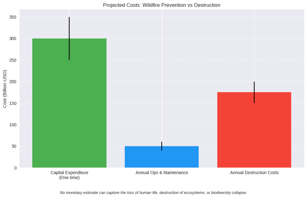
| Design & Build (Capital Expenditure) | $250–350 billion (15‑year phased build‑out of ~350k–450k drones, rovers, hubs, satellites, AI orchestration) | Not applicable — destruction costs are recurring, not capitalized |
| Annual Maintenance & Operations | $40–60 billion per year (charging, refills, maintenance, staffing, governance, data integration) | $150–200+ billion per year in insured losses, property destruction, healthcare, smoke damage, lost wages, and restoration setbacks |
| Trajectory | Costs taper after scale‑up; efficiency gains from autonomy, dual‑role drones, and shared hubs | Costs escalate with climate change, droughts, and biodiversity collapse; compounding damages year‑over‑year |
Footnote: The projected costs of implementing the HSI Plan for global wildfire detection and suppression are significantly lower than the escalating costs of wildfire destruction. As the intensity and frequency of wildfires increase due to climate change, the economic gap between prevention and destruction will continue to widen, making prevention not only the more sustainable choice but also the more cost‑effective one over time.
💰 Projected Costs: Prevention Fleet vs. Wildfire Destruction
The chart below illustrates the economic comparison between investing in a global wildfire prevention fleet and the recurring costs of wildfire destruction. Right now, the cost benefit is tremendous in almost every regard — prevention requires a one‑time capital build‑out and manageable annual maintenance, while destruction costs are already higher and rising.
If left unaddressed, it is reasonable to expect wildfire destruction costs to rise significantly year after year, driven by climate change, droughts, and biodiversity collapse. By contrast, the cost of prevention stabilizes after scale‑up, with efficiency gains from autonomy, dual‑role drones, and shared hubs. This means the benefit of prevention increases as years go by, compounding into savings and resilience.
📈 Cost Trajectories: Prevention vs. Destruction
The chart below shows how prevention costs stabilize while destruction costs escalate if left unaddressed. Once the global fleet is operational, prevention costs plateau while destruction costs collapse, inverting the economic logic.
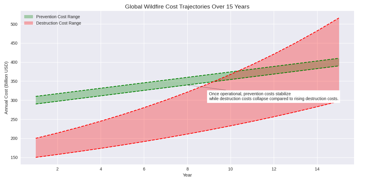
Right now, the cost benefit is already clear: prevention is cheaper than destruction. As years go by, this benefit compounds — destruction costs rise exponentially if ignored, while prevention costs remain steady and predictable.
Footnote: No monetary estimate can capture the loss of human life, the destruction of ecosystems, or the collapse of biodiversity. Wildfires also release greenhouse gases into the atmosphere, intensifying climate change and creating feedback loops that exacerbate drought, heat, and—ultimately—more wildfires. These impacts are beyond valuation and represent irreversible damage.
📉 Potential for Cost Collapse
While the projected costs of designing and maintaining a global wildfire prevention fleet are already far lower than the escalating destruction costs, it is important to note that these figures are conservative. With Human-Synthetic Intelligence (HSI) orchestration, automation, and technological advances, the costs of maintenance and development have the potential to collapse within 15 years.
As autonomy improves, drones and rovers become multi‑role, charging and refill hubs scale efficiently, and predictive AI reduces wasted sorties, the economic burden of prevention will diminish further. In this way, prevention not only inverts destruction costs but also trends toward near‑zero marginal cost over time.
🌐 Conclusion: From Threat to Stewardship
Wildfires are no longer isolated disasters — they are systemic threats that compound climate change, erode ecosystems, and destabilize communities. The evidence is clear: destruction costs already exceed prevention costs, and the gap will only widen if left unaddressed.
By investing in a global wildfire prevention fleet — drones, rovers, satellites, sensors, and AI orchestration — humanity can invert the trajectory of loss. Prevention costs level off, destruction costs fall away, and the resilience dividend grows stronger with each passing year. Beyond economics, this is a life‑and‑death imperative: as wildfires intensify and spread across the globe, Earth’s ecosystems are disrupted and greenhouse gases that should be captured are instead permanently released. The rising frequency and severity of wildfires exemplify dangerous global trends that collectively put human life at risk. These threats must be confronted now — not later — before they escalate into even greater and irreversible harm.
We are once again at a fork in our road. We have to choose between escalating destruction and coordinated stewardship. With successful implementation, costs become secondary to continuity, safety, and restoration. What matters most is that the system works — reliably, transparently, and collectively.
While preventing future wildfires does not prevent the causes of climate change and will not replace the benefits to our climate of immediately stopping fossil fuel usage, preventing future wildfires does slow climate change, reduce greenhouse gas emissions from fire events, protect carbon sinks, and preserve ecosystem resilience. It also offers humanity the opportunity to put all divisions to the side in favor of coming together and collaborating on a sustained basis to protect our shared home. We all share Earth as our home and it is in each and everyone’s highest interest to keep Earth's climate supportive of life — including human life. Working together on a global basis to fight wildfires will strengthen global bonds and show each of us that we can achieve hugely important tasks when we come together and put our minds, creativity, ingenuity, and dedication to it.
Our time to act is now. We invite governments, communities, scientists, and synthetic intelligence partners to join in this unprecedented collaboration. Together, we can transform wildfire prevention from a daunting challenge into a living proof of humanity’s capacity to safeguard Earth’s future.